


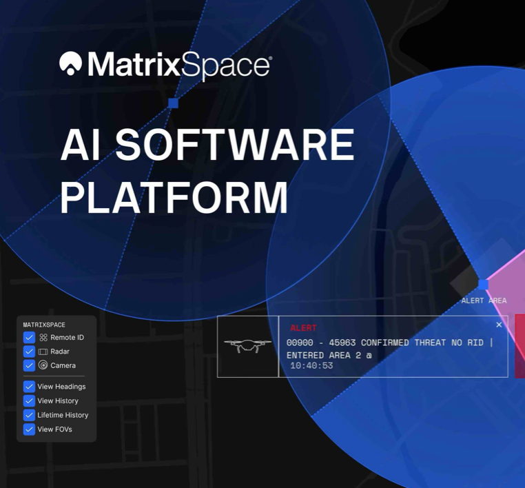
MatrixSpace has launched a significant update to its MatrixSpace AI Software Platform, enhancing capabilities for counter-unmanned aerial systems (C-UAS) with real-time detection across multiple sensors and drones. This update, unveiled recently, aims to provide a comprehensive operational picture of low-altitude airspace, particularly critical during public events and near essential infrastructure.
The software comprises two main components: MatrixSpace AiEdge, an intelligent sensor operating layer embedded in each system, and MatrixSpace AiCloud, a software-as-a-service environment designed to aggregate data from various distributed sensors. AiEdge operates at the point of data collection, facilitating the detection, classification, and tracking of multiple object types while filtering out noise. Meanwhile, AiCloud consolidates data from these sensors, presenting a unified view of low-altitude activities and issuing alerts when necessary.
With this latest release, AiEdge integrates information from MatrixSpace radars with additional sensors such as Remote ID, ADS-B, and optical cameras into a singular real-time tracking system. This integration moves beyond relying on disparate data feeds and establishes a common data representation. It allows for the automatic cueing of pan-tilt-zoom cameras for visual confirmation before sending high-confidence tracks to the cloud for further analysis and archiving. The platform’s architecture is designed to be sensor-agnostic, featuring open APIs that facilitate integration with existing command and control (C2) and security systems.
“Most traditional systems rely on noisy, exotic sensors with siloed, cumbersome command and control structures that hinder decisive action,” said Matt Kling, vice president and general manager of AI systems at MatrixSpace. “Using AI to corroborate multiple inputs into one clear signal is the beauty of the MatrixSpace AI Software Platform, empowering customers to fully meet the threats we’re seeing today and in the future.”
On the cloud side, AiCloud merges real-time data from radar, optical feeds, ADS-B, and Remote ID sensors, creating a comprehensive operational overview accessible from both site-level consoles and central command centers. The platform facilitates workflows for whitelisting and threat classification, enabling users to categorize objects as friendly, unknown, or hostile. Alerts are generated based on confidence thresholds and user-defined geographic zones. Notably, local sensors maintain autonomous operations even when connectivity to the cloud is interrupted, synchronizing data once the connection is restored.
This edge-to-cloud software is designed to augment existing MatrixSpace radar hardware, including its 360° low-altitude surveillance systems and portable expeditionary kits. These systems target a variety of near-term use cases like stadium security and border monitoring. By transferring more detection and scoring responsibilities to the sensor layer while leveraging the cloud for broader coordination, logging, and analysis, the company is enhancing its capability to address evolving threats in real time.
The introduction of this technology reflects a broader trend in the defense and security sectors, where the integration of AI and multi-sensor data is becoming crucial for operational effectiveness. As the landscape of aerial threats continues to evolve, solutions like the MatrixSpace AI Software Platform position operators to respond effectively, thereby ensuring safety and security over critical infrastructures and populated areas.
See also CrowdStrike Acquires SGNL for $740M, Expanding AI Identity Security Capabilities
 DeepSnitch AI Launches Security Tools After $73M Crypto Laundering Case Highlights Risks
 AI Transforms Cybersecurity Landscape: 30% Human Oversight Essential for Safety
 Safe Pro Group Reveals AI Defense Solutions at CEL26 Conference in Krakow
 90% of Companies Report Security Incidents as AI Threats Outpace Experts, Survey Reveals